
A rare red weather warning is in effect – and last night was likely the hottest June night on record. Follow the latest as the heatwave continues.
New June heat record set – again
Yet another June record has been set today, with temperatures reaching 36.1C in Gosport, Hampshire.
That surpasses the 36C recorded earlier today in the same location and in Wisley, Surrey.
A 50-year-old 35.6C record was first broken at around 4pm today, with 35.7C recorded in Charlwood, Surrey.Hosepipe ban in effect in Kent, says South East Water
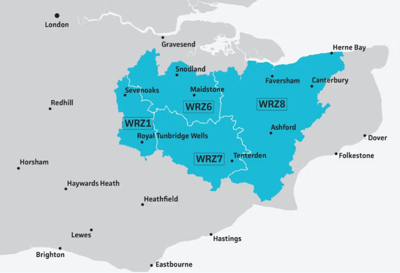
South East Water has introduced a hosepipe ban in Kent over “record demand for water” during the heatwave.
In place until 3 July, the temporary ban means residents in affected areas should not use hosepipes for watering gardens, washing cars, patios and boats, nor for filling swimming and paddling pools.
South East Water
“Our teams have worked incredibly hard to prepare for this summer,” the water company said, “but the sheer scale of this sustained heatwave means water is being drawn from our storage tanks faster than it can physically be treated and refilled.
“Our absolute priority has to be making sure there is always enough water for everyone’s essential daily needs – like hygiene, drinking and cooking – and that we protect our vulnerable customers.”
How did the Met Office record the hottest June day ever?
You might be wondering how exactly these temperatures we’re reporting on are recorded by the Met Office.
In 2022, amid all-time highs of 40C, the weather agency explained how they calculate the maximum temperature records.
Since the 1960s, Met Office temperatures have come from stations “that meet specific criteria and are regularly maintained and inspected by our specialist teams”.
Only data measured to the nearest decimal point is included, the Met Office said, limiting the locations that can be used in standardised results.
“Within these stations, thermometers have to be housed in a white slatted box with its door facing north, called a Stevenson screen, which keeps the thermometer away from direct sunlight but air flow constant,” the agency added, noting that these must be kept consistent across sites.
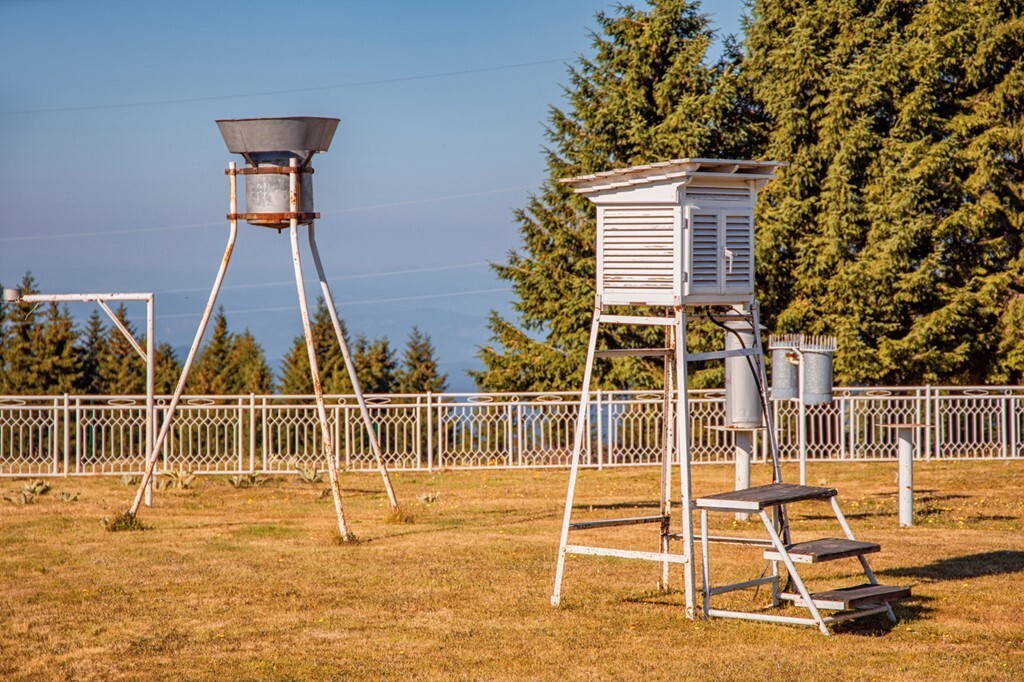
When it comes to officially recognising the maximum temperatures, the Met Office added: “There is a verification process to the daily real-time data, which has to go through quality control prior to its release, such as cross-referencing with nearby stations for any inconsistencies.
“However, for records to become official, more rigorous quality control is carried out over a longer period of time, potentially several months, before they can be recognised as a new record.”
That’s why the Met Office is saying “provisionally” when it reports these temperatures – confirmation can take between weeks and months.
We and other news outlets have been using these figures as they’re highly accurate and often published live by the Met Office as it gets them.
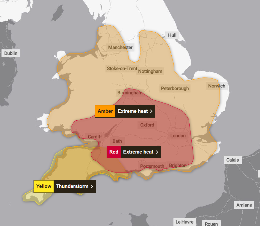
Three weather warnings in effect today – with thunderstorms forecast in South West
Three weather warnings are in effect today, with a new yellow alert for thunderstorms issued in England’s South West.
Met Office
That thunderstorm alert covers Cornwall, Devon, Dorset, Plymouth, Somerset and Torbay from 6pm to midnight.
It comes alongside the already-issued amber and red extreme heat warnings.
The red warning – only the second time such an alert has been issued for heat – is in effect until midnight tonight.
The red warning is in place for the following regions:
- London & South East England
- East of England
- East Midlands
- South West England
- Wales
- West Midlands
Here’s what people should expect, according to the Met Office:
- Population-wide adverse health effects experienced, not limited to those most vulnerable to extreme heat, leading to serious illness or danger to life.
- Substantial changes in working practices and daily routines will be required.
- High risk of failure of heat-sensitive systems and equipment, with the loss of power and other essential services, such as water, electricity, gas or mobile phone services.
- Significantly more people visiting coastal areas, lakes and rivers, leading to an increased risk of water safety incidents.
- Delays on roads and road closures, along with delays and cancellations to rail and air travel, with significant welfare issues for those who experience even moderate delays.
Meanwhile, the wider amber warning for extreme heat is set to last through to Saturday, gradually shrinking into the east as the weekend begins.
Yeovil is one of a few areas in the south west affected by all three weather alerts today.
2 hour ago2h ago11:33
UK sweats through what’s likely to be warmest June night on record
The UK has provisionally had its warmest June night on record, with temperatures breaking a record set in 1976.
It was 23.5C overnight at Cardiff and Bute Park, making for the warmest ever June night in Wales and the UK generally.
The record has also likely been broken in Plymouth, where temperatures hit 23C.
These both break the 1976 record of 22.7C, much like yesterday’s high of 36.1C broke the hottest-ever June day record.
For context: These are provisional figures, with official confirmation set to come by 10am.
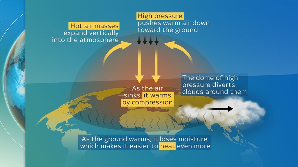
Explained: What is a ‘heat dome’?
We’ve already seen 50-year-old heat records broken yesterday, with plenty of chances for them to be broken again.
Temperatures are edging dangerously close to levels previously thought almost unimaginable in the UK, according to the University of Reading.
Dr Akshay Deoras explained that the “driving force behind this event is a heat dome”.
But what is a heat dome?
Well, it’s when an area of high pressure stays over a large part of a region for days, or even weeks.
Like a lid on a saucepan, it traps hot air underneath and can cause heatwaves with temperatures well above the norm.
How does a heat dome form?
Hot air expands vertically into the atmosphere, then high pressure from above means it has nowhere to escape and pushes that warm air down.
As the warm air sinks, it compresses and heats up, which then traps more heat underneath.